|
20.5.2004
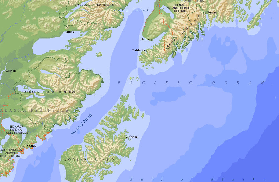
Homer, Alaska, USA
Leaving on Friday seems to mean bad weather - at least for us. Again
it was raining, four days straight. But we were pleased that we left,
because a day's hesitation, and we would stayed to wait for better
weather. Once you have left, it's not so bad. Two days we soaked in the
cockipit, heading west. Pete's Pass, Mc Arthur's Pass
and Nuka Passage - three narrow passages cutting high
peninsulas cutted the distance a bit. Then being wet was enough, and we
anchored for two days, waiting the rain to stop. Hannu fixed the main
sail cover and Auli wrote.
|

We saw big logs drifting. Dangerous!
Have to avoid night sailings.
|

Clouds
are hanging low, it's +7 C / 42 F.
A log behind the boat.
|
On Tuesday the sky cleared
and we sailed to Port Chatham, a sheltered bay 40 miles from
Homer. For the first time we found razor clams. They dig down, escaping
your shovel, which is kind of odd thing to do of a shellfish. Razor clams
are considered especially tasteful. However, Hannu liked more the small,
round clams, we also found. Port Chatham has six meters (22 ft) tide,
 a vague hint what to expect in Cook
Inlet and Anchorage, where the maximum tide in May is 36.9 feet (11
meters)! So despite its name, there is no anchorage or harbour for small
craft in Anchorage. Big tides mean of course fast currents, and you have
to time your going. Cook Inlet is considered one of the
nasty places because of the shallow waters, strong currents and sometimes
unpredictable weather.
The weather was fine this time, when we motored into the Cook Inlet
towards Homer. First it was calm and sunny, then calm and
foggy. The harbour of Homer is located on the end of a 4 mile long sand
spit, named simply "The Spit". The harbour and enterprises
gatherend around it are the economic source for the 5000 inhabitants'
Homer. The harbour is home for over thousand boats, both commercial
fishing vessels and tourist/charter boats. The harbour fee was an
unpleasant surprise: 28 dollars per night! Ten bucks more than the most
expensive harbour we have met in Alaska. We hope to get everything done
quickly.
|

Eddies in Cook
Inlet. Our speed was 7-8 knots with the current.
|
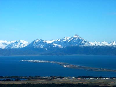
Four miles long Homer Spit is a
tourist and fishing centre.
|
A month we have experienced
easterly winds, but now the weather system has changed. During the
summers there is a stationary high over the North Pacific. It's on its
place now, which means southerly and southwesterly winds - headwinds for
us. Well, we were aware of this.
23.5.2004
Homer, Alaska
Four days has gone fast. We have met all our Homer-friends: Phil,
Don, Lilli and Bruce. It was a big surprise to meet Bruce here, we
thought he was still in Cordova. Hannu was walking in the harbour when
he saw Bruce's car (you cannot make a mistake with that one). Everybody
has been very helpful and kind, so things have sorted out with speed and
we also have had a lot of fun.
Phil visited us the first evening with bunch of fishing
tips and lures. He works for the Fish
and Game, and knows fish and fishing. Phil is for instance estimating
the age of fish, which is done from the balance (or hearing) organ/bone.
The oldest fish they have caught was 200 years old!
One morning (at 5 am) Don took Hannu out for fishing.
Hannu got his first king salmon, about 30 pounds, and a good size
halibut. It took a few hours for Auli to can the salmon, and now we have
a good supply of the most delicious salmon.
|
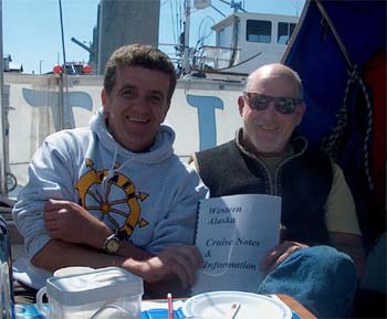
Don invited his friend Pete, who has
been working as a pilot for 14 years on the Aleutian Islands and
the Bering Sea, to tell us about the area. We got excellent tips
on anchorages, currents, fishing villages, harbours, and
interesting places. There are caves, hot springs, petrofied
forests, mummies and of course a lot of spots to watch wildlife.
We are even more excited about the Aleuts than before.
|

|
On Saturday we drove with Bruce,
Lilli and the dogs out of Homer to their property. It's in the
forest, so we had to drive 7 miles with Argo to get there. A bark beetle
has made enourmous disaster: vast areas of spruce forest is dead, the
trees are standing grey and sad. Bruce is building a two-storey cabin
alongside a small river. As a metall man, he has welded a steelframe
inside an old wooden cabin. Hmm...very special solution. The day was
beautiful and we enjoyed a real summer weather for the first time. The
birds were singing and the birch trees blushed green. We didn't come
back empty handed: we picked a bag of morels (or brain mushrooms as
someone know it) and a bag of nettles. The locals probably don't eat
morels, because they are poisonous, but after removing the toxine by
cooking (5 min. twice, spooling between), they are a delicatess. The
fresh, small nettles made a tasty sauce with the halibut.
j
Bruce and his cabin construction.
On the background you can see dead spruce trees.
29.5.2004 Geographic
Harbor, Alaska (58°06' N 154°36' W)
Click to enlargen
the map!
The topic of the past week is weather and weather forecasts. A bit
more unusual wind for summer season, easterly, was blowing when we left
Homer. Good, we thought, we make over the Cook Inlet right away. The
forecast in Monday morning said NE 20, perfect for us. The weather
forecast is a continuous recording on VHF, on special weather channels
(all the areas have own frequences). We have a US hand-held VHF with
installed weather channels under one button. Most of the European VHFs don't have these frequenses,
neither some other channels like 22A used by the US Coast Guard. But back
to the Cook Inlet. We were happily on our way over the Inlet, and listened
to the forecast later in the morning. Now it said NE 35, galewarning.
Between Kenai Peninsula and Kodiak there are the Barren Islands, which increase
the strenght of currents and wind.
It's a tricky area and we didn't want to mess with it in bad weather. So
we decided to go to Port Chatham (59°13' N 151°45' W). In
the afternoon we listened the weather again: nothing about any warnings, SW 15 - actually the current situation, because the day was gone
already. Well, it was calm in our anchorage as well. We were mad about the
wrong forecast, so we kept a short diary for a few days. The area is
probably difficult to predict, but in that case the forecast could be more
limited. In New Zealand the weather forecasts are given only for 18 hours
ahead.
Below are the wind forecasts given between Monday evening and Wednesday morning
for a week ahead to area 3A, Barren Islands ja Kamisak Bay:
|
Mo eve |
Tue
morn |
Tue
eve |
Wed
morn |
| TUE |
SW 25 |
W 25
-> 15 |
SW 15 |
|
| WED |
NW 15
-> W 15 |
variable
-> W 20 |
W 20
-> SW 20 |
variable
-> S 20 |
| THU |
SE 20 |
SW 15 |
SE 25 |
SE 25
-> E 30 |
| FRI |
E 15 |
SW 15 |
SE 25 |
SE 25 |
| SAT |
N 15 |
variable |
NE 20 |
NE 15 |
| SUN |
|
|
W 20 |
N 15 |
Especially Wednesday (26.5.)
and Friday (28.5.) seemed to be hard: for Wednesday it was predicted
both variable and wind between NW and S. For Friday the direction of the
wind was jumping from east to SW and finally to SE. What really happened
was, that on Tuesday it was variable, on Wednesday it started to blow
SW, increasing to 15-20 knots, before it calmed. On Thursday a low
affected the area and gave strong NE winds, about 25-35 knots.

In addition to VHF forecasts we take weather
faxes by SSB radio.
Above a part of fax given on the 28.5. The centre of the low is on
Kodiak.
Left from it you see the Alaska
Peninsula and the Aleutians.
We left Port Chatham on
Wednesday. We were very tired after four busy days in Homer. The days had
been full from morning to evening: fishing, canning, preparing mushrooms,
celebrating Auli's birthday, baking a birthday cake, updating the
homepage, sending mail and having fun with friends. The SW wind gathered
gradually speed on Wednesday, which turned our course to Shuayk
Island (58 34 N 152 29
W). The north tip has several small bays and shallow waterways, so we
made a paddling trip in the evening. Four "land" otters were
snorting to us, and unintentionally we scared some geese away.
On Thursday morning we found our way out between the rocks and feeding humpback
whales to the Shelikoff strait (again one infamous area of
water). We made all the way, 77.5. miles, over to the Geographic
Bay, mostly motorsailing, in the end motoring. Half past nine in
the evening we anchored behind a small island. Geographic Harbor is the
place where we spent unforgettable three days last August watching
bears fishing (see the photos). And bears we
saw also now. Already from far we saw one walking on the white sandy
beach. Now the bears were by one or two, eating grass or digging on a
beach, unlike in August when all were gathered by the river to fish
salmon. When we were looking for an anchorage we saw a mother nursing a
cub on a tip of a small island. They didn't care although we were very
near, the small one didn't even stop sucking. Geographic Bay is part of
Katmai National Park and an amount of tourists visit the place. We
anchored in the lee of bear's island and sat in the cockpit for a while
looking at them. Then it was time to go to bed.
We had been sleeping only an hour, when the expected NE wind started to
blow, and the anchor dragged. Clothes on and out to the dark and rain.
After couple of tries the CQR stuckked. The whole chain (50 m) was out in
15 meter's depth. At the same time a fishing vessel arrived aided by very
strong spotlight. They anchored near us. (Didn't answear VHF the next day,
hmph.) We put the GPS anchor guard on and went back to restless sleep.
The wind and rain continued the next day. The wind shifted a bit and we
had to look for a better place in the afternoon. Geographic Habor is a
long and narrow bay, surrounded by high mountains, which increases the
wind strength and shifts it locally. However, there are many low islets,
where you can find shelter. The night was spent in a new anchorage, but
early in the morning the wind shifted again, and it was impossible to
sleep. The boat rocked and wind howled, but this spot had an even sand
bottom with good hold (35 m chain in 15 metres). At six in the morning
we changed the anchorage once more, driving into a big and deep bay, where
we found an area of sand in 15 metres.
The wind has decreased during the day, and tomorrow we are able to
continue. Shelikoff has only few good anchorages far apart. The next all
weather place is Agripina Bay 90 miles away. There are
couple of anchorages in between but they are not usable on easterly wind.
The days are long, so 90 miles goes in daylight. We don't want to sail
during the night, partly because of the drift logs, and just because we
want to be comfortable.
Arvo was asking after the lat/lon of the anchorages, so I have added them.
Antti asked about the temperature. It's nice and brisk, about + 7-10 C /
42-50 F! Winter overalls, cloves, hats, long underwear and double fleece
jackets - and you are warm.
You can find weather information in the internet: http://pafc.arh.noaa.gov/marfcst.php
Easy address, isn't it!
31.5. Agripina Bay (57 07 N 156 28 W)
I was going to update the above on Saturday, but the satellite phone
couldn't find satellites behind the Geographic Harbor's high mountains.
Yesterday's sailing was salty and wet, no chance to any "office"
work.
Forecast said N 25, but it was NW - 50 at its best. When the white top of
a wave is spraying up in the wind, you know it blows! Our anemometer is
still broken, maybe better so. The 90 miles to Agripina went in 14 hours,
hand steering.
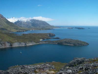
This is very beautiful bay. The scenery comes close what I believe is on
Aleutians: no trees, only low, green hills and small bays filled with
white drift wood. Caribou or some other deer was standing on a hill when
we arrived. We were looking at it so eagerly by binoculars, that we almost
drove on a shoal. The animal left when we started to clatter and rattel
with the anchor chain. Agripina can be seen on the above map, just in the low
left corner, after the big bay (Wide Bay).
Agripina Bay
I still have to tell one happening from the Geographic Harbor. When the
rain finally stopped in the afternoon, we went for a walk to the beach. We
felt safer there than in a forest, at least you could see the possible
bear from far. First we saw beartracks. They were huge, bigger we ever
have seen. Then a fox entered the beach. I though it will run away as soon
as it sees us, but no. The fox jogged towards us, sat down only 3 metres
(9 ft) apart and scratched itself! Its golden fur was in a bit poor
condition, but the long tail was brushy and fine, all the way to the white
tip. The fox stared at us with its slanting eyes, sniffed a couple of
times and continued its unhurried going. We didn't have cameras with us.
But the picture is saved in my memory: the cunning look on the gracefull,
triangle shape face.
8.6.2004
Chignik, Alaska,
USA (56º18' N 158º24' W)
The coastline on the Alaska Peninsula is broken by shoals and rocks,
islands and islets. In some parts the shore is steep, mountains rising
directly from the sea, elsewhere the shoreline opens to wide and shallow
bays. Sheltered anchorages are few. Our previous place, Agripina Bay,
lies 90 miles from Chignik, a small fishing settlement, where we are at
the moment.
Here are two fish producing companies, and a constant traffic of fishing
vessels bringing their catch in. This time of the year it's mainly red
salmon, which spawns in the nearby Chignik Lagoon. The town has a
school, postal service, a short airstrip, and a phone box. The other
fishing company maintains a shop. That's all. Not one single bar, not
even a church! This is a place where people come to work. They live in
company houses and eat in the company canteen, which serves meals four
times a day, one in the midnight. You hear a lot of Spanish around:
Mexicans have found their way up here to work.
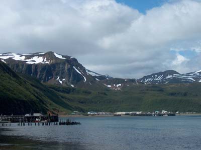
Chignik is located in a very beautiful bay. Green hills around, behind
them mountains, still having some snow on their peaks. Several
waterfalls. I don't know if there has been a native village some time,
but you could imagine that. A beautiful spot with lot of fish nearby.
Chignik
The weather forecast has been annoyingly precise lately. (Just when we
were complaining!) It has been blowing hard, this time from SW. It seems
that we make progress only once a week, between the gales. Anchor Bay,
where Chignik is located, is not a good anchorage. The bay is wide and
deep, the bottom soft mud. Williwaws make boats to drag their anchors.
Yesterday the wind rose in couple of minutes so that the whole bay was
full of white caps. All the vessels on the bay - a big state trooper's
aluminium boat, a ship, and us - dragged. We couldn't find a spot to
re-anchor in that wind, so we tied alongside a rusty barge, where
fishermen keep and maintain their nets.
Castle Point. Border between wx area 5A and 5B.
11.6.2004 Sand Point,
Alaska, USA (55º 20 'N 160º 30' W)
Luckily we didn't have to wait a whole week in Chignik. We sailed on Wednesday, even the forecast
promised SW 25. We concluded by the air pressure
and weather fax that the weather pattern has already changed. It's
impossible to say inside the Chignik Bay how the sea and wind are out
there.
We had correct. On Wednesday it was calm and on Thursday we had east
wind. It was great to sail the whole day. Near Kodiak a low pressure
deepened to 983 mb and for Friday Kodiak waters got a storm warning, 50
knots. Nice to be away from there!
Sand Point, a fishing village with 1000 inhabitants, is located
on the Shumagin Islands. The islands, eight bigger and
several smaller, are named after seaman Nikita Shumagin,
who died in scurvy on the Nagai Island in 1741. He sailed
with Vitus Bering and was first of the many scurvy victims
aboard. We planned to sail first to Nagai, but looking at the wind
prediction we decided to sail first to Popof Island where
the shelter harbor of Sand Point lies. It has been a while, three
weeks almost, since we last moored by a dock, near facilities. Although
we have sailed almost 500 miles from Homer - trees are gone and the
shoreline is rugged - we still have 2-3 daysails to the Aleutian
Islands.
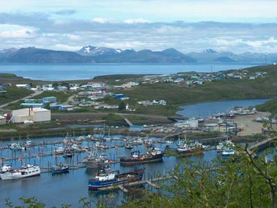
Sand Point consists of different size and colour wooden houses on
completely treeless land. Welcome was friendly. The harbour office was
closed on Friday because of the memorial day of president Ronald Reagan, but
we could tie up next to a local fisherman.
Sand Point, Popof, Shumagin Islands
 |
Shumagin
Islands are in the middle. Sand Point is located between Unga ja
Popof.
NE from the Shumagins you can see Chignik and Perryville, an
Indian village. There is no harbour, so the locals take their
boats up to a river on a high tide.
West from the Shumagin Is. you see the first Aleutian island,
Unimak. The next bigger one (outside the map) is Unalaska, where
Dutch Harbor is located.
Passages between the Aleutian Islands join the Bering Sea with
Pacific Ocean. Passages have strong currents, even 12 knots have
been measured.
The Aleutian chain reaches 1000 miles west.
|
Vitus
Jonassen Bering (1681-1741) was Danish, a son of a non-wealthy
clergy man. Vitus was supposed to be a priest too, but the family had no
money for his education, and the son went out to the sea. In his
twenties Vitus joined the Russian navy. That wasn't so odd choice,
because Denmark was allied with Russia against Sweden in the Great
Nordic war (or the Swedish War, 1700-21). Bering distinguished in the
navy and his success was noted by the Czar Peter the Great, who
nominated Bering as the commander of the first Kamchatka expedition. The
purpose of the expedition was to explore the American continent, because
Russia was looking opportunities to expand its power to east. The strait
between Asia and America (which later got Bering's name) had been found
already in 1648 by Semon Deznjov.
Bering got to bit off more than he could chew. He was not an explorer,
although an experienced seafarer. Bering's destiny was to fulfill to
disasterous expeditions. However, Bering was a brilliant organiser -
that was his merit in the war also - and this talent was both needed and
used during the preparations of the two voyages. The ships were built in
Siberia, 7000 km from St. Petersburg. Bering was able to transport
hundreds of men and thousands of tons gear, material and supplies
accross Siberia.
The first sailing voyage took only some summer months in 1728. Bering
sailed along the coastline towards north, up to 67. latitude. There he
turned around, never seeing the coast of America, only about 40 miles
apart but covered by fog. St. Petersburg was not pleased with Bering's
results.
Despite that - or because Bering was given another chance - he was
nominated as the commander of the second Kamchatka expedition in 1731.
This time two ships were built in Siberia, St. Peter and St.
Paul. The latter was commanded by Alexei Chirikov, who
sailed with Bering already on his first trip. The preparations of the
second expedition were huge, much greater than for the first one. At the
first time, the expedition sailed after three years work, now it took
ten years. In June 1741, the ships sailed towards east. A town,
Petropavlovsk, had grown to the site.
If Bering was totally
lacking enthusiasm for exploring and finding the new, that quality was
the driving force of young German natural scientist Georg Wilhelm Steller
(1709-46). He talked himself to join Bering's voyage. All the important
achievements of the second expedition - observations and notes on
animals, plants and people - were made by Steller. And those were made
after hard negotiations. Steller had to beg and threat Bering to let him
go ashore. On their first landfall, on Kayak Island near Cordova,
Steller was allowed to spend only 10 hours ashore. Bering took a climpse
of the land and went back to his cabin. He suffered of scurvy. But
during their last landfall Steller had good time for his scientific
work, since the ship wrecked on an uninhabited island and the men had to
spend the whole winter there. Bering died on the island in December
1741. The island was named after him. Next spring the rest of the crew
built a small vessel using the material of St. Peter. They managed to
sail back to Kamchatka in August 1742.
A bunch of North Pacific animals are named after Steller. He was the
first to observe and classify them according the western science. One of
them - still alive and numerous - is the Steller sealion, often seen in
these waters. Another, Steller seacow, was hunted to extinction in
1760's. Steller prepared a complete skeleton of a seacow on Bering
Island, but was no allowed to take it aboard the small vessel they'd
built. Only three complete skeletons exist today, one of them in the
collections of the University of Helsinki.
Sources:
Corey Ford: Where the sea breaks its back. 1966.
Matti Lainema & Juha Nurminen: Ultima Thule. 2001.
WSOY Facta 2001.
18.6.2004 King Cove,
Alaska, USA
We left Sand Point on Monday and sailed 20 miles east to Nagai. The
islands is like an oak leaf or multi-legged kecko: several capes stick
out both sides from the long body. Moss and small plants are covering
the hills as well as dense areas of birch bushes which hindered longer
hikes.
Bering's ship St. Peter anchored in 1741 on the
east side of Nagai. It was 60 miles from our west shore anchorage, so we
didn't go there. The crew took water on Nagai, from a tidewater pool
near the shore, so it was a bit salty. Steller noted that and told that
there was fresh stream water, but the sailors didn't care and filled the
casks. The bad water made scurvy patients' condition even worse. Near
Nagai St.Peter also met the first locals, the Aleuts, who paddled
with their kayaks.
From Nagai we sailed (really sailed again, now the wind was easterly!)
to Unga Island. We visited the abandoned Unga village. I don't know when
people have left the place. In our pilotbook, printed in 1992, the
village exists with a school, a church and several stores. The houses
were collapsed and gardens wild. We found a big area full of strawberry
flowers - I wish there would have been berries already! We saw buffalo
droppings and saw one animal far away. Buffalos and cows were brought
into Shumagin Islands. When we left Sand Point we saw some ten buffalos.
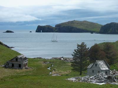
Abandoned Unga village. The elephant rock
on the backround.
Next day we
continued to the north tip of Unga to see some petrofied wood.
Pilot Pete had tipped us about this one, and the place was great!
Various sizes of white "stonewood" were lying on the beach -
looking like wood with annual growth rings and branch holes, but they
were stone. It would be very interesting to know when petrofying has
happened. Encyclopedia knows only the petrofied forest in Arizona and
that is 200 million years old. Wow! I wonder how old these trunks are.
If someone knows, send us an e-mail. It would also be interesting to
know if the process was same than in Arizona: the trees died normally
and were buried by soil. The soil was penetrated by water rich of
silica, and gradually silica and other minerals replaced the wood
fibers.
|

White pieces are petrofied wood
|

The beach was full of different
sizes and shapes of petrofied wood
|
We left the Shumagin Islands
and continued west. King Cove wll be our next and last stop before the
Aleutians.
Next |