|
15.11.2001 Illinois River, USA
After two weeks in Chicago, and six months on our way, we were off on
Monday, the 12th of Nov., to the 1200 mile long river voyage to the Gulf of
Mexico. We will be driving along six different rivers: Chicago, Illinois,
Mississippi, Ohio, Tennessee and Tombigbee. Instead of our first plan of driving
the whole way along the mighty Mississippi, we are taking the Tenn-Tom waterway,
which means that we leave the Mississippi River in St. Louis. Tenn-Tom is said to be
more interesting and safe. Instead of New Orleans, we end up to Mobile, some
miles more east of the Gulf coast.
During the last week in Chicago we had good company: Italian sailor Laura with
her two dogs arrived (see the log on 9.10.). It was really a pleasure to change
experinces and get to know her. She tasted reindeer at the first time in her
life, and we had a treat with Italian delicatess on her boat. We also have to
thank once again our friend Bill, who took care of us during our stay in
Chicago.
The Windy city was a positive experience, but the tele-communication facilities
were really poor. Datacalls were not available most of the time, and when they
were, the speed was a ridiculous 9600 bauds. (That's why the long pause in the
updating.)
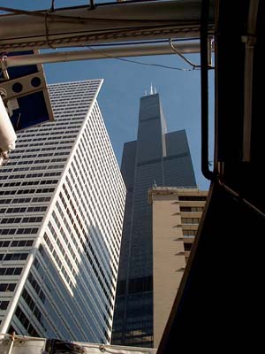
The last glance to the town was made under the bridges, because the Chicago River runs through the downtown and under about 45 bridges.
|

With the flag pole our height is
4,5 metres
|
|
The first experiences on the Illinois
River remines those of our friends, who are on the Amazon River at the
moment: water is brown and bottom is near. The first day we hit the ground three
times. Fortunately the bottom is soft, so we got Kristiina free, although we
don't have a mast from where to drag out a halyard to heave the boat. We even
have two flies inside the cabin, but the temperature is somewhat different than
on the Amazon; about +10 C in the morning and round +20 C during the day.
Because of the shallow waters, it has been difficult to find a dockage or
anchorage. We spent one night alongside an old lock wall, an other beside a
barge, and the third one anchoring, since we found enough depth off the route.
The tugs and barges are the kings of the these rivers. The tow boats are pushing
some 18 big barges full of sand or coal, so you just can imagine the weight -
and the distance needed to stop from 4-5 knots speed. The tugs have 6000 hp
engines and propellers about 3 meters in diameter. Along the riverside are
located various industry and loading stations for crain, sand, gas, coal and
chip.
Illinois River has seven locks, that take you 48 meters down to the level of
Mississippi. Lockage is slow because of the barges. The whole load is too big
for the 180 meter long and 30 meter wide lock, so the first six barges go first,
are winched out, and then comes the rest.

An evening on the Illinois river
21.11.2001, Mississippi River, USA
After four days, we began to wonder the miles on the chart and on our log.
The U.S. Army Corps of Engineers are
responsible for the inland waterways and navigational charts. The mile used on
their chart is a statute mile (1.6. kilometers), not a nautical mile, as we
took for granted. Our mistake shortens the way from 1255 nautical miles to 1115
nm.
We stopped in Peoria for two nights. The 100.000 inhabitant's town is the center
for agriculture and industry in Illinois. The city also seemed to be the center
for spiritual and physical treatment, it was full of churches and church
hospitals.

300 metres of barge
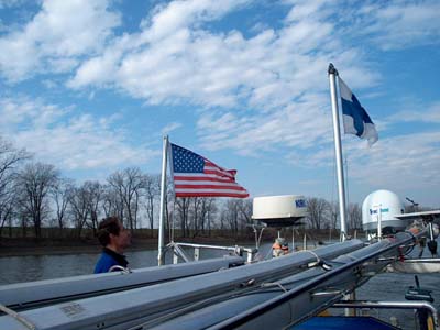
We have hoisted the spinnaker bom as a
flagpole, flying the Finnish flag on top and the U.S. courtesy flag on side, as
it would be on it's normal place under the spreader. This was not the proper
way, we were told by a tow boat skipper. "No flag above the American flag",
is the rule.
But having the U.S. flag above our national flag makes us an American boat,
which we are not. Our intention was not to be unpolite, but have the flags
according the international watercraft rules. In America we have our own rules,
said the skipper, and told that he had called the Coast Guard, which shared his
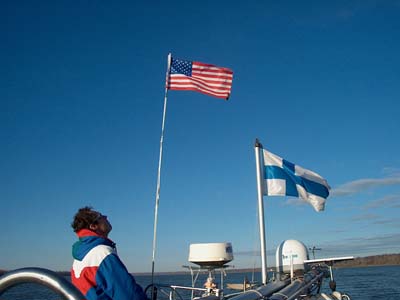
opinion. We solved the problem by making an own flagpole for the American flag,
so now both flags are on the top of their own poles. However, our national flag
is bigger and therefore flying higher.
Will this due?
One morning the Perkins would not start. Hannu managed to start the engine with
a screwdriver, but then he discovered that the charger is overloading the
batteries. The controller was broken. We turned all the electrical devices on, to
gain maximum consumption, and to avoid stopping. So, there we motored, in the
bright daylight, with all the 18 cabin lights, tv screen and the electrical
heater on!

We found deep enough side river
On Monday (19.11.) at 12.20 we entered the wide Mississippi River, feeling a bit
sad for leaving behind the narrow and beautiful Illinois River and it's forestry shores with
deers, storks, beavers and white-head eagles. But at last we had reached the
"real" river of Huckleberry Finn and Jim, although the traffic has
grown up since their times. We passed St. Louis with 2.5 million people, there
was no place to stop.

St. Louis
27.11.2001 Ohio River, USA
Mississippi River is much broader an deeper than Illinois, and the flow is
faster. It gave Kristiina extra speed and we were making 9-10 knots, sometimes
even 11 knots. There are strong whirlpools which make the boat toss. Safe places
to stop are rare, there are just a few marinas, and some safe anchorages can be
found. The water level can rise several
meters, over ten in a worst case. Now in November the water level is at lowest,
and it's hard to imagine that the river can rise up to the shore hills and reach
the towns. Most of the towns have a flood wall. This part of Mississippi has two
locks, that lowered us 11 meters.
We have been making 30-50 nautical miles in a day. There is daylight from seven
am to five pm. It's best to move during the day, although the towboats are
clearly visible also in the dark because of their strong spotlights.
|

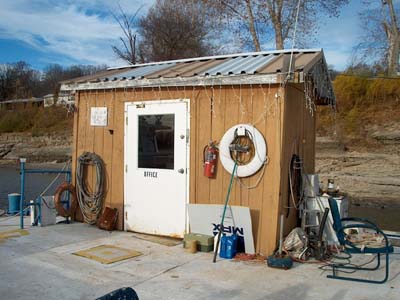
"A marina" can be two
barges along the riverside.
The main thing is that it offers a safe stop.
|
Hoppie's marina office
|
A couple of nights were busy. We were going to
spend a night beside a dock at the Kaskasia lock, but the lockmaster said
that after the terrorist attack it's no longer allowed to stay there. But we
could anchor above the lock. So we went through the lock and anchored. In the
middle of the night Auli woke up to motor noise and bright lights. Three motor
boats were driving around Kristiina and spotting us with the lights. Then they
vanished into a small river. It was a hunting gang, it's the deer hunting
season.
For the next night we anchored in safe and sheltered river diversion. There was
already a big, 77-feet house boat, Misty-R, which we had met
earlier at the Hoppie's Marina. There we helped them with the ropes and tried to
start a conversation, but for the skipper we were air, he ignored us. A
thunderstorm broke out at the night, and we stood up to watch the storm. Auli
had already gone back to warm bed, when Hannu shouted that the motor boat is
coming on to us! Their anchor had loosen. The speed was not fast, since the flow
was slow, and there was no wind. But the over 20 meters long and perhaps 20 ton
boat would have done a great damage to Kristiina. We had no time to get our
anchor up and drive away, so Hannu started to blow the horn like mad. Just
before they hit us, they managed to start the engine and drive away. Manouvering
in the narrow space made them to almost hit us again. We had VHF on waiting for
some kind of comment or thank, but nothing, the radio remained silent. In the
morning they passed us without stopping, waving or anything. The VHF was silent.
Misty-R remains a mystery. It was a dangerous place to miss the anchor, without
us they might have ended under a tow boat.
On the Ohio River we got the current
against us. Speed reduced to 5-6 knots. During the first day a hard wind was
blowing from behind helping us, but it also rised quite big and sharp waves. The
Ohio is even broader, at least on this spot, than the Mississippi.
We missed Cairo, as did Huck and Jim because of the fog - we saw the town
clearly, but there was no place to tie the boat up. We passed two locks, which
took us up again, about seven meters.
Just before the Tennessee River we stopped at Paducah,
a 100.000 inhabitants town. There is a marina, Big E, with
rumbling and rolling floating docks, but it is a marina, a safe place to stop.
It was really nice to be able to get out of the boat after three day's
anchorage.
A remark on the height of the flag poles
caused this version
5.12.2001
Tennessee River, USA
After all, we spent three days in Paducah and got a lot of things done. As a
journalist, Auli got herself onboard a tow boat, Jeffrey J. It was
without cargo, but still a very interesting experience, thanks to James
Marine and skipper Tommy!
Located near four rivers (Mississippi, Ohio, Tennessee and Cumberland) Paducah
is a center for tow boat companies. About 20 companies have their office in the
town, and there is also shipyards and other facilities.
The tow boat I was on, assists the local traffic and transports some short
distance cargo. A typical job would be assissting in the lockage: when a
15-barge tow wants to use the small chamber in the lock to avoid the long
waiting for the big chamber, the cargo has to be split and Jeffrey J. would take
half of the barges through the lock.
After leaving Paducah it was raining for two days and nights. The river level
went up one meter and a lot of wood, from small parts to big trees, were
drifting with the flow. At the end of Tennessee River (it starts in Knoxville
and flows to Ohio) is the Kentucky Lock, which took us 16 meters up. After the
lock we entered the 300 kilometers long man-made Kentucky Lake. The
numerous coves and bays offer beautiful and deep anchorages. Along the east
shoreline are several state parks with great nature and wild life. When the rain
stopped we went for a walk to the forest and in one cove we met Carl, who was
preparing the next day's duck hunting. We spent the evening with Carl sitting
beside a big camp fire, the full moon lighted up the forest around us and the
wolves were howling. Carl told that it is a small red wolf, living in these
forests. There are also deers, raccoons and possums, by the water live beavers
and otters, and in addition to the already familiar white head eagles and blue
storks, we saw kingfishers. The lake scenery is more varied than on the previous
rivers, there are hills and limestone cliffs. We passed a few marinas with
several sailing boats, not wonder, because the Kentucky Lake offers a fine
sailing area.
After the rain, we got blue skies and warm sun. The temperature falls near the
zero during the night, but the sun gets it up to around 20 C. This difference
means also fog in the morning, and we were happy to have our radar installed.
Also the Tennessee River is very beautiful and has a variable scenery from the
reddish brown cliffs and green cedar trees to the fields and lowlands. With the
leaves in the summertime, it must be even more beautiful.
The evening of the first of December we drove in to the Cuba Landing Marina,
where people were getting ready for a Christmas party. We were invited. After a
long longed shower (the last time was in Peoria over two weeks ago), we joined
the party and tasted the delicacies people had brought with them. The drinks
were on the house. It was very different Christmas Party compared to a Finnish
one: around 8 pm people strted to leave and by 9 pm the harbour was quiet. Well,
it was easy to get up at six o'clock next morning and enter the river again.
13.12.2001
Tenn-Tom Waterway, USA
We have now left the Tennessee River behind us, and we have ahead the last,
720 kilometers long part before the Gulf of Mexico and Mobile. Tennessee-Tombigbee
Waterway consists of 374 kilometers long canal joining to Black Warrior
and Tombigbee rivers. The Tenn-Tom canal with its 12 locks is a bigger
construction than the Panama canal. Earth was digged and moved one thrid more
than in Panama, 307 million cubic yards. The total lift is 102 meters and the
highest lock the Bay Springs with 25 meters lift.
Already the early explorers, like frenchman Montcalm, suggested building a canal
to join the inland river Tennessee and the Gulf rivers together. Similar
proposals were made and plans drawn during the centuries and decades, but every
project was too massive and too expensive. The building of Kentucky and Pickwick
dams on the 1930's gave a boost to the project, and in 1946 a decision was made
to build the canal. However, it took almost 30 years before the construction
work got started in 1972. The Tenn-Tom canal was opened in 1985. It runs through
the states of Mississippi and Alabama.
The Kentucky Lake was beautiful, but there are two other lakes on our route, Pickwick
and Bays Springs. Both are man-made. The scenery is even more beautiful
and there are plenty of sheltered and fine anchorages, where we have spent some
time.
On the Pickwick Lake we stopped for one night near the dam and lock.
Storks and kingfishers were on the spot, as well as small brown divers we did
not regonise. It was nice to walk in the forest for a while. The shores were
full of deer foor prints.
In the next, a bit bigger cove, we spent two nights, also celebrating Finland's
Independent Day (6.12.) by having a sauna. In the eve of the Day, but
already the 6th in Finland, we were heating up our tent sauna, sitting by the
camp fire and staring at the odd star constellations. We had left the ceramic
oven stones in Greenland, so now we had some washed American river stones. In
the calm and warm night the sauna was warming up quickly. But a loud pang-pang
noise started in the tent. The stones did not tolerate the heat, and were
cracking and flying around the tent. No matter what, we wanted a sauna! We hided
behind the oven lock, but Auli got a couple of hot shots before the fireing
stopped. After that we had a good and hot sauna bath.
We also played music by Jean Sibelius - for all the animals in the nearby
darkness as well.
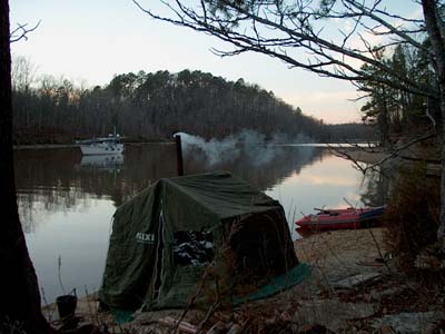
From Pickwick Lake we motored 30 nm to the Bay Springs Lake, which
had even more sheltered anchorages. This lake is the youngest of the three
man-man lakes, so maybe that is the reason for the extraordinary shape. It is
like an oak leaf, full of bays and coves, from where opens new and new, smaller
and smaller coves. And they are deep - it's a lake full of perfect anchorages.
The earth is red sand, and the shores are cut by erosion. There is a lot of pine
trees, which makes the winter landscape more colorful. Auli saw a special
animal: a turtle.
We were out of food and water, and it was about the time to send the Christmas
mail to Finland. So we stopped for one day in the Bay
Springs Marina and drove with their courtesy car to Booneville, 30 miles
away. With loads of food, water tanks full, and with clean laundry we spent two
more days in the beautiful cove on the lake.
Tenn-Tom Waterway is quite boring
canal-motoring, but we got some change by visiting a 1860's plantation mansion
and a steam-wheelboat. The building of the Waverly Mansion in the state
of Mississippi was finished just before the civil war. All the six sons of the
family joined the war for the Southern troops. The plantation was a village in
itself with post office and mills. During the best times, a thousand people,
slaves and tenant farmers with their families, lived there. The four floor high,
white painted pine wooden house was glorious, but rather small for the ten
children family. There were five bedrooms. The kitchen was located separately
from the house, to prevent the main building from fire and heat.
The steam-powered sternwheeler Montgomery was built in 1926, and used
until 1982. The use of coal was changed to diesel at some point. Montgomery was
a snagboat, it removed trees, sunken logs and other debris in the river. The 53
meter boat had a crew of 12-14 men.
20.12.2001
Tombigbee, Alabama, USA
Only 300 kilometers (220 statute miles), which is about 3-4 days drive from
Mobile, we faced first time the river's force and had to live on it's
conditions. The two days rain caused a flood and the river was running about six
knots. That extra speed would have been nice, but the river was full of logs,
trees, branches, grass and debris. It was not safe to go out, said the locals.
Even if the solid steel hull of Kristiina would take the hits, the propeller,
shaft and rudder were in danger. It would not be nice to drift without steering
in that speed, maybe a towboat coming behind the next corner.
For a lucky coincidence, we would have stopped for a couple of days anyway,
because we were meeting Auli's friend Ingjerd from Norway in Demopolis. We took
a day trip to Moundville to see the ruins of an indian village. Only the big
mounds, covered by grass were left. It is not exactly known why the indians
built these hillocks.
Auli started the Christmas cleaning by washing the white ceilings of Kristiina
so eagerly, that her back was hurting a couple of days afterwards. The odd
position jammed the muscles. So, it was no hurry to the river.
We did some Christmas shopping at the Wal-Mart: both of us got 20 dollars and a
half an hour. A couple of times we met at the same department... well, we'll
see at the Christmas Eve, did we also buy the same things. That happened last
Christmas, when both of us bought the Heavy Weather Sailing book for the other.
On Tuesday, the 18th of Dec., after spending five days at the Demopolis marina,
we were off to the river, which still had a six knot current and quite much
things in it. The day was clear and sunny, so it was easy to see the logs and trees. But we
were exhausted after seven hours attentive steering.
The underwater buoys are the most dangerous. A couple of times a buoy pumped up just beside the boat,
sinking slowly under the flow again. We have an old chart missing some buoys.
It's impossible to say where the edge of the sailing line or route is, because
of the widened river.
Now, on the third day, the flow has diminished reducing our speed from 11 knots
to 9 knots, and there is not as much debris as when we left Demopolis. The
shores began to be green, and there are little palms among the trees.
Between Demopolis and Mobile are two locks with together a 74 feet lift. On
Wednesday, we came through the last lock, so we are on the sea level now.
It will be interesting to see when the tide effect begins. On the St. Lawrence
river, at the beginning of our inland route, the tide was effecting as far as
300 nautical miles, up to Quebec. Four months ago we left the salty water, so it
is time to go back to the sea, step the masts, and sail again!
About a hundred kilometers (64 statute miles) before Mobile we took an off-river
route to look for an overnight anchorage. We motored about 20 minutes along the
sideriver, when we saw a bay. But it was actually not a bay, but a wood
clearing. There was seven meters depth, so we kept going into the woods. It was
a real forest with thick trees, some having spanish moss hanging on them. Birds
and squirrels were making noises up on the tops, but there were no land animals,
because there was no land! Amazing place. We motored among the trees, depth
keeping at 5-7 meters all the time. We had to stop when it turned so dense that we
couldn't get Kristiina in. How many of you have droven a sailboat into a forest!? We tied the stern to a tree, and there was so much water beside it,
that we could back Kristiina next to it. Incredible!
 |
 |
It is only a few days to the Christmas,
so it's time to say
MERRY CHRISTMAS
AND HAPPY NEW YEAR!

It is nice to know that we are not
alone out here, but with all of you. Sharing the experiences via the log book
has been a pleasure, and we hope the same of reading it. Despite the language
mistakes and irregular updates.
Previous
- Next
|